Front country - easily accessible
Loop
Undulating, small hills only
Dog Friendly
Other
Gravel Road
Moderate Single Track
Average Uphill Gradient: +6.0%
Average Downhill Gradient: -6.0%
VIP Feature: Send this route to your Garmin account so you can follow the course on your Garmin device.
Login as a VIP to see the trailhead information.
2:15
Slow
1:45
Moderate
1:15
Fast
Start up Forestry road where the gate is (usually closed). You can park hard to the left of road to leave room for any vehicles just make sure the gate can fully open up. You'll quickly hang a left into the forest and continue via 50/50 mix of gravel roads and forest trails.
There's a few gradients in the mix but nothing too difficult.
A couple of kms before the finish you will cross over your original trail to end up on Forestry Rd again, back to the gate.
If you know of any public toilets near the trail start or on the route, please login and then let us know so we can update this section.
Side of Forestry Rd allowing for vehicles to pass by.
3 km
4 minutes
Yes
No
Hard.
Take a watch with a GPX map as trails are easy to miss.
Patchy.
Windproof jacket, First aid kit, Cellphone, Map
Not suitable.
Muddy after rain but generally dry after a few days of sun.
The odd logging truck on the roads - wear a high-vis top.
Hallertau Brewery
1171 Coatesville Riverhead Highway, Auckland
https://hallertau.co.nz/
Trail Legend
Login as a VIP to become a Trail Legend. Learn about Trail Legends.
Fastest Known Times (FKTs)
You and 
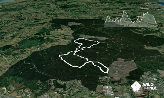
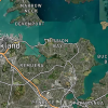
Riverhead Forestry Road 14KM
As a VIP member you can record private notes for this trail, see all of your times and more.
Already have an account? Login now
1 star at present, because continued logging makes it very hard to navigate and negotiate the bottom loop. I missed the second turnoff (if this was intended to be Stroopwafel mountain bike track) the first time and ended up 2km down Long Bush Road. The second attempt I made it up to Barlow Road (the logging spoil was not as bad as previous reviews made out) but then failed to find Magnum track. After a number of attempts and with worsening weather I bailed. With zero chance of finding the top end of Stroopwafel and a steep drop off I elected to run back down Barlow to Lind Road and back along Long Bush again.
There is the option of missing Magnum by running more on Barlow, but I can't say how far the logging stretched into the forest. I would avoid this trail for now, but if you must run it I suggest avoiding the lower loop completely and doing an up and back on the roads I took to come back to the car.
January 25
Take the second left after the Forestry Road gate. As per Bruce's comment, the tree felling means you have to pick your way through about 300m of slash to connect up to another forest access road, but it's pretty easy going. The rest of the trail is pretty good underfoot at the moment.
March 31, 2024
Be aware that the start of the trail has been deforested recently so you'll need to go around or pick your way through it for about 200m.
January 8, 2024
These overlap with this trail to some degree. You may wish to combine them but please note that to qualify for FKTs on these runs you should record a separate activity for each.