Last Updated: 25th Jul 2024
Run Forest Run!
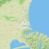
Riverhead, Auckland
Last Updated: 25th Jul 2024
Grunt Factor: 26 ?
Gnarl Factor: 67 ?
17.7km
430m
425m


Last Updated: 25th Jul 2024
Last Updated: 25th Jul 2024
Grunt Factor: 26 ?
Gnarl Factor: 67 ?
17.7km
430m
425m
Front country - easily accessible
Loop
Undulating, some big hills
Dog Friendly
Plantation/exotic forest
Gravel Road
Moderate Single Track
Technical Single Track
Average Uphill Gradient: +4.9%
Average Downhill Gradient: -4.8%
VIP Feature: Send this route to your Garmin account so you can follow the course on your Garmin device.
Login as a VIP to see the trailhead information.
Not suitable
Slow
2:30
Moderate
2
Fast
Needing a longer pure trail Riverhead route? This one is a good workout with great variety and almost zero forestry roads (we love that). Around 450m altitude gain to get the thighs working. Can you spot 'Snowy' the dog??
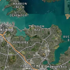
Starting at the Barlow Rd entrance run about 200m straight and then look for the trail entrance on your right. This is great trail that undulates through the forest with easy up and down sections lasting for 3km. Eventually you will cross onto ‘Strip Rd-Skid 2’ being a gravel road section. It immediately forks to the right for a few hundred meters before you turn left back into the forest trail.
Now you’re on the famous ‘Baconator’ trail that takes you a couple of kilometres to meeting with Barlow Rd again. It’s a short steep climb up to the road. Turn right and in a 100m turn a sharp left almost back in on itself and you will be on a long stretch of open trail. This can get very slippery when wet as it’s a clay-based track called ‘Pink Bits’.
We are around the 6km mark now, out in the open with great views following the clay trail down and straight across Hansons Rd. Just before the 8km mark you will turn hard left and cross a small stream. There’s no bridge so you’ll get a bit wet. Follow the trail to the right here as it winds its way up through the forest – be careful to follow your GPX map here as there are multiple turns and other trails. Cross over ANZAC Rd at 9.5kms.
The trail takes a north-west turn here until 12kms when you will shortly turn hard left onto Campbell Rd heading back towards the main road. Just before you reach the edge of the forest turn left off the road and onto the trail. Normally this is the final stretch back to Barlow Rd entrance however after just 500m you will turn left and up a rough-formed road to the 14km mark. This next stretch that turns south-west is again a very nice undulating trail with some good altitude gains throughout.
Be careful around the 15km mark as it’s easy to end up climbing a grueling bike track rather than the parallel running track. Don’t worry if you get it wrong as they both converge at the top anyway.
The last two kms are mostly downhill where you’ll finish back at Barlow Rd.
If you know of any public toilets near the trail start or on the route, please login and then let us know so we can update this section.
Lots of parking space. Haven't heard of any break-ins at all.
11 km
11 minutes
Yes
No
Hard.
Need the GPX on your watch.
Patchy.
Long-sleeved thermal top, Seam-sealed waterproof jacket, Beanie/thermal headwear, First aid kit, Cellphone, Map
Muddy spots after rain - also a couple of large puddles can form on the flat open area of route.
Trail Legend
Login as a VIP to become a Trail Legend. Learn about Trail Legends.
Fastest Known Times (FKTs)
You and Run Forest Run!
As a VIP member you can record private notes for this trail, see all of your times and more.
Already have an account? Login now
Great addition to the Riverhead trails. Only got lost a couple of times. GPX is definitely your friend.
August 8, 2024
These overlap with this trail to some degree. You may wish to combine them but please note that to qualify for FKTs on these runs you should record a separate activity for each.
Send to your phone
Scan the below QR code to open this trail on your phone.

Tip: position the QR code in your phone camera screen.