Last Updated: 21st Sep 2023

Experienced

Save Trail Save

I've done it Done

Two Thumb Track, Rangitata to Round Hill Ski-field.

Geraldine, Canterbury

Submitted by David Mavor

Last Updated: 21st Sep 2023

Experienced

Save Trail Save

I've done it Done

Grunt Factor: 104 ?

Gnarl Factor: 82 ?

49.0km

2320m

1940m

1900m


Login as a VIP to see driving directions, distance and time.

Trail Map

Type of Run

Back country - remote

Point to Point (one way)

Undulating, some big hills

Open tussock/grasslands

Open ridges/tops

Run Makeup

5%
75%
20%

Farm Road / 4WD Track

Technical Single Track

Untracked / Route only

Average Uphill Gradient: +10.5%

Average Downhill Gradient: -8.7%

Trailhead

Login as a VIP to see the trailhead information.

Estimated Times to Run

Not suitable

Slow

10:30

Moderate

07:00

Fast

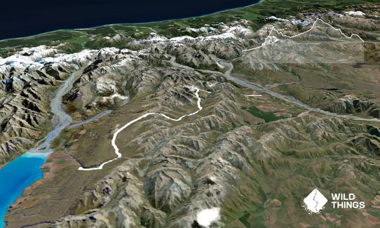
Follow Bush Stream to the Crooked Spur Hut (2hrs, 10km). There are multiple river crossings.

Care needs to be taken at Sawtooth Bluff, 5km from carpark. There are markers on the true right to a high water route.

The Hut is high up on a spur, 10km from the carpark. A poled route over a 1500m saddle to the Stone Hut (2hrs, 10km) and then onto the Royal hut (1hr, 6km).

The route then climbs steeply to Stag Saddle (2hrs, 4km) 1925m. There is cell phone coverage here.

It is possible in clear weather, to descend towards the ski-field via the ridge on your right. A poor weather option is in the valley poled route. A steep climb from Camp stream Hut up to Round Hill ski road (20km, 3hrs).

Classic Musterers Huts, Stag saddle (1900m) is the highest point on the Te Araroa Trail. Great views of Lake Tekapo.

If you know of any public toilets near the trail start or on the route, please login and then let us know so we can update this section.

Access to the carpark is at the end of Rangitata Gorge Road. Not much traffic on your way out, you will need to arrange transport from each end of the run.

74 km

1:15:00 minutes

Unknown

No

Hard.

Generally well poled except Bush Stream and Ridge-decent off Stag saddle.

Very patchy.

Waterproof leggings, Thermal leggings, Short-sleeved thermal top, Long-sleeved thermal top, Seam-sealed waterproof jacket, Windproof jacket, Gloves, Beanie/thermal headwear, Personal Locator Beacon (PLB), Whistle, First aid kit, Extra food for emergencies, Survival bag, Cellphone, Map, Headtorch and spare batteries

There is good water available following streams on route except over Stag saddle.

Summer and Autumn best.

There are high river levels in spring due to snow thaw.

You and Two Thumb Track, Rangitata to Round Hill Ski-field.

As a VIP member you can record private notes for this trail, see all of your times and more.

Register Now

Already have an account? Login now

Trail Reviews

Be the first to submit a review for Two Thumb Track, Rangitata to Round Hill Ski-field.!

Login to submit a review

Trail Running Community

Find people who are interested in or have completed this trail run.

You must register or login to view this feature.

Register Now

Other trails nearby
A-Peeling!

A-Peeling!

Length: 7.5km

Level: Beginner - Intermediate

Big Mt Peel

Big Mt Peel

Length: 23.7km

Level: Intermediate - Experienced

Te Moana short loop

Te Moana short loop

Length: 14.0km

Level: Beginner

Kakahu Bush Reserve

Kakahu Bush Reserve

Length: 9.0km

Level: Beginner - Intermediate

Find more trails and peaks nearby