Last Updated: 11th Apr 2025
Mount Nimrod loop track
Submitted by Martin Trvaj
Last Updated: 11th Apr 2025
Open
Grunt Factor: 13 ?
Gnarl Factor: 40 ?
6.7km
385m
385m


Last Updated: 11th Apr 2025
Submitted by Martin Trvaj
Last Updated: 11th Apr 2025
Open
Grunt Factor: 13 ?
Gnarl Factor: 40 ?
6.7km
385m
385m
Front country - easily accessible
Loop
Undulating, small hills only
Native bush
Beach
Open ridges/tops
Easy Single Track
Moderate Single Track
Average Uphill Gradient: +11.6%
Average Downhill Gradient: -11.5%
VIP Feature: Send this route to your Garmin account so you can follow the course on your Garmin device.
Login as a VIP to see the trailhead information.
1:40
Slow
1:20
Moderate
1
Fast
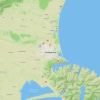
Starting from the car park (clockwise), the loop track goes through the forest and steadily climbs towards rocky knolls with views of the coast.
The track then descends to Nimrod Stream, which you'll need to cross. A short detour upstream leads to a 15-meter waterfall (watch out for slippery rocks).
After that, the track climbs sharply to a lookout before descending back to the camping area, completing the loop.
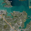
Views of the ocean.
At campsite.
DOC campsite, so enough place to park.
13 km
31 minutes
No
No
Easy.
Follow the orange markers.
Generally good.
Waterproof leggings, Lightweight fleece top, Short-sleeved thermal top, Long-sleeved thermal top, Seam-sealed waterproof jacket, Windproof jacket, Gloves, Beanie/thermal headwear, Whistle, First aid kit, Extra food for emergencies, Cellphone, Map, Headtorch and spare batteries
At DOC campsite before you start.
Could be muddy.
Muddy and slippery, and Wallabies.
Fastest Known Times (FKTs)
You and Mount Nimrod loop track
As a VIP member you can record private notes for this trail, see all of your times and more.
Already have an account? Login now
These overlap with this trail to some degree. You may wish to combine them but please note that to qualify for FKTs on these runs you should record a separate activity for each.
Send to your phone
Scan the below QR code to open this trail on your phone.

Tip: position the QR code in your phone camera screen.