Last Updated: 23rd Sep 2024

Beginner - Intermediate

Save Trail Save

I've done it Done

Woolshed Creek Hut via 4wd route

Mt Somers Village, Canterbury

Submitted by Sonja Vreugdenhil

Last Updated: 23rd Sep 2024

Beginner - Intermediate

Save Trail Save

I've done it Done

Open

Grunt Factor: 16 ?

Gnarl Factor: 28 ?

10.0km

505m

500m

920m


Login as a VIP to see driving directions, distance and time.

Trail Map

Type of Run

Front country - easily accessible

Out and Back

Very hilly

Native bush

Open tussock/grasslands

Run Makeup

50%
50%

Farm Road / 4WD Track

Moderate Single Track

Average Uphill Gradient: +10.0%

Average Downhill Gradient: -9.9%

Trailhead

Login as a VIP to see the trailhead information.

Estimated Times to Run

3:00

Slow

1:30

Moderate

1:00

Fast

Mt Somers track is well signposted. From the Carpark - follow the signs to Woolshed Creek Hut. There is an intersection by a fence where you can go straight to continue on single track or left to continue on the 4wd track. Take the left hand track and follow the track to the hut.

At the hut there is a creek where water can be filled up from the stream and a toilet if needed.

There are a few short detours on the track where it is possible to see old coal mine remains.

Flush toilets at the start of the track, long drop at the turn around point Woolshed Creek Hut.

Ample car parking at the start of the track. Some cellphone reception at the carpark.

0 km

0 minutes

No

No

Moderate.

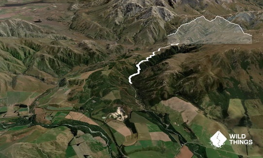
Follow the track from Woolshed Creek Carpark to Woolshed Creek hut.
At the intersection by the fence, take the left hand route to the 4wd track - this is signposted with an orange arrow.

Very patchy.

Lightweight fleece top, Seam-sealed waterproof jacket, Gloves, Whistle, First aid kit, Extra food for emergencies, Cellphone, Map

Some water available at Woolshed Creek Hut.

Over winter this area can be prone to snowfall and icy conditions.

Trail Legend

GS

Gaylene Saywell

has completed Woolshed Creek Hut via 4wd route twice in the last year.

Learn about Trail Legends.

You and Woolshed Creek Hut via 4wd route

As a VIP member you can record private notes for this trail, see all of your times and more.

Register Now

Already have an account? Login now

Trail Reviews

Be the first to submit a review for Woolshed Creek Hut via 4wd route!

Login to submit a review

Trail Running Community

Find people who are interested in or have completed this trail run.

You must register or login to view this feature.

Register Now

Overlapping Trails

These overlap with this trail to some degree. You may wish to combine them but please note that to qualify for FKTs on these runs you should record a separate activity for each.

Mt Somers Woolshed Loop

Mt Somers Woolshed Loop

Length: 14.7km

Level: Beginner - Intermediate

Mt Somers - Over the Top V1

Mt Somers - Over the Top V1

Length: 21.0km

Level: Intermediate

Woolshed, Bus Stop Loop

Woolshed, Bus Stop Loop

Length: 11.6km

Level: Intermediate

Mount Somers over the back

Mount Somers over the back

Length: 17.6km

Level: Intermediate

Other trails nearby
Mt Guy

Mt Guy

Length: 9.6km

Level: Intermediate

Roundabout Emma

Roundabout Emma

Length: 15.0km

Level: Beginner

Looping Mt Harper

Looping Mt Harper

Length: 19.5km

Level: Intermediate - Experienced

Clent Eastward in “Barrosa”

Clent Eastward in “Barrosa”

Length: 26.3km

Level: Intermediate - Experienced

Find more trails and peaks nearby