Last Updated: 21st Sep 2023

Beginner

Save Trail Save

I've done it Done

Ōtātara Pā Historic Reserve

Napier, Hawkes Bay

Submitted by Kate Southern

Last Updated: 21st Sep 2023

Beginner

Save Trail Save

I've done it Done

Open

Grunt Factor: 5 ?

Gnarl Factor: 20 ?

3.5km

195m

195m

127m


Login as a VIP to see driving directions, distance and time.

Trail Map

Type of Run

Urban

Loop

Undulating, some big hills

Open tussock/grasslands

Run Makeup

100%

Easy Single Track

Average Uphill Gradient: +10.9%

Average Downhill Gradient: -11.6%

Garmin Course

VIP Feature: Send this route to your Garmin account so you can follow the course on your Garmin device.

Send to Garmin

Learn about sending to Garmin.

Trailhead

Login as a VIP to see the trailhead information.

Estimated Times to Run

0:40

Slow

0:30

Moderate

0:20

Fast

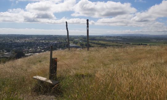
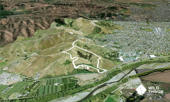
Enter the walkway from Churchill Dr, heading uphill. The trail starts off as dirt track but after climbing a stile to enter the reserve, you will be running on a wide mown path amongst the grass. Follow the the trail around to the right, and around the 'back side' of the hill. Follow the path which will take you down to the waharoa (pā gateway and carpark). Be sure to check out the modern reconstruction of the pallisades and info signs along the way.

Once you reach the carpark, head straight across (away from the road) and look for the sign that says "Maggies Way". It is quite overgrown but still in use. Climb the stile and follow the track back up the hill. The trail is much narrower and with long grass, take care with foot placement to avoid any ankle rolls. Head up the hill, climb the stile at the junction with the mown grass path you were running on previously, turn right, and return back towards Churchill drive using the same mown grass path.

Very easy to navigate around here. You won't get lost. Enjoy the view and don't forget your sunscreen!
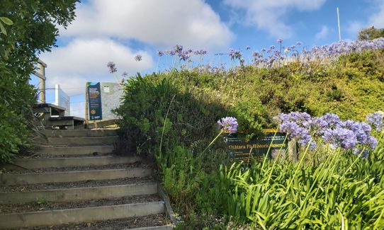
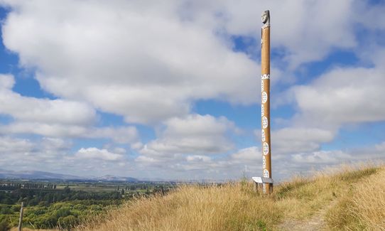
Ōtātara Pā Historic Reserve is one of the largest and most ancient Māori pā sites in Hawke’s Bay. It comprises 58 ha, and incorporates two pā sites: Ōtātara Pā (on the lower portion of the hill) and Hikurangi Pā, 500 m higher up the ridge. It is administered by the Department of Conservation in partnership with the local hapū, Ngāti Pārau (one of the hapū within the Ahuriri Hapū) as kaitiaki (guardians) of the reserve. You will see restoration work including palisades and pouwhenua, and archaeological features such as tūāpapa, whare and rua kūmara. Enjoy the expansive views and reflect on why the site was chosen for its strategic position. Take time to read the story of Ōtātara Pā, depicted by the Turauwha Pou – part of the Te Ara o Nga Tipuna (Pathways of our Ancestors) project. Sites of battles, deaths or burials are considered wāhi tapu (sacred) by Māori. Feel free to wander and look but please treat the pā areas with respect. All archaeological and physical features of the pā are protected by law. Respect our cultural heritage: do not consume food on the pā, and keep to the track. Above all, remember “Toitū te whenua” – leave the land undisturbed.

If you know of any public toilets near the trail start or on the route, please login and then let us know so we can update this section.

Park on Churchill Road

7 km

8 minutes

Unknown

No

Easy.

Generally good.

Windproof jacket, First aid kit, Cellphone

None

Exposed to wind and sun.

Fences may be electrified for stock.

You and Ōtātara Pā Historic Reserve

As a VIP member you can record private notes for this trail, see all of your times and more.

Register Now

Already have an account? Login now

Trail Reviews

Nice views and a bit of history.

Rob Holm

April 5, 2023

Nice bit of hill work and well worth visiting. Bring the family and do a couple of loops whilst they walk at their own pace.

Anthony Sowerby

January 5, 2022

Login to submit a review

Trail Running Community

Find people who are interested in or have completed this trail run.

You must register or login to view this feature.

Register Now

Other trails nearby
To the Puketapu Pub!

To the Puketapu Pub!

Length: 16.3km

Level: Beginner

Rockin' the Mill

Rockin' the Mill

Length: 22.0km

Level: Beginner - Intermediate

Bell Hill Loop

Bell Hill Loop

Length: 7.5km

Level: Beginner

Tangoio Tumbler

Tangoio Tumbler

Length: 9.7km

Level: Beginner

Find more trails and peaks nearby