Last Updated: 21st Sep 2023

Beginner

Save Trail Save

I've done it Done

Waipunga Fling

Napier, Hawkes Bay

Submitted by Melissa Franklin

Last Updated: 21st Sep 2023

Beginner

Save Trail Save

I've done it Done

Notice More info

Grunt Factor: 10 ?

Gnarl Factor: 16 ?

8.0km

255m

255m

101m


Login as a VIP to see driving directions, distance and time.

Trail Map

Type of Run

Urban fringe

Loop

Undulating, small hills only

Plantation/exotic forest

Run Makeup

5%
95%

Gravel Road

Easy Single Track

Average Uphill Gradient: +7.4%

Average Downhill Gradient: -7.5%

Trailhead

Login as a VIP to see the trailhead information.

Estimated Times to Run

1:15

Slow

1:00

Moderate

0:45

Fast

This is call "fling" because its a nice little introduction to the Eskdale MTB park. Remember to buy a vistors permit ($10) from any bike shop in the bay or the four square in Bayview. You can also get a yearly membership if your prefer, but the permit gives you 3 weeks access. You can also get a map of the park if you need to help with navigation.

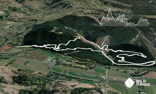
From the start at Waipunga Rd run straight up the shingle road and head for Blink, Barley and Twoman tracks. These are followed by Bypass and a short shingle road section to the bottom of Lower Magog. Continue up Lower Magog until Thistle which joins Bolt. Bolt will exit on to the shingle road, turn left and run the road until a track (Merv's) starts on your right. Follow this track until it exits by the tanks. Head up the road past the tanks to find DH link track. Run this track and find Blink and it will exit you back on to the road, run back to gate.
Pine forest

If you know of any public toilets near the trail start or on the route, please login and then let us know so we can update this section.

Parking on side of road. I wouldn't leave valuables in you car.

21 km

20 minutes

Unknown

No

Easy.

Just look for signs and you should be right

Generally good.

Long-sleeved thermal top, Seam-sealed waterproof jacket, Gloves, Beanie/thermal headwear, Whistle, First aid kit, Extra food for emergencies, Cellphone, Map

none

Cold in forest in winter. Muddy when wet.

Look for fallen branches an pine cones as well as the odd MTB rider!

You and Waipunga Fling

As a VIP member you can record private notes for this trail, see all of your times and more.

Register Now

Already have an account? Login now

Trail Reviews

Nice forest running, great on the day I ran it as it was 28 degrees in the sun so the shade was perfect. I highly recommend you get a map of the trails as many are not marked at all and there doesn’t appear to be an online version... hence my run was a bit longer than the one described but still fun. Will be back with a map to explore some more!

Mike Tennent

January 24, 2018

Login to submit a review

Trail Running Community

Find people who are interested in or have completed this trail run.

You must register or login to view this feature.

Register Now

Other trails nearby
Tangoio Tumbler

Tangoio Tumbler

Length: 9.7km

Level: Beginner

Once Was An Island

Once Was An Island

Length: 8.4km

Level: Beginner

Tutira trig

Tutira trig

Length: 8.6km

Level: Beginner - Intermediate

Westshore Conservation Loop

Westshore Conservation Loop

Length: 5.9km

Level: Beginner

Find more trails and peaks nearby