Last Updated: 9th Sep 2024

Beginner

Save Trail Save

I've done it Done

Westshore Conservation Loop

Napier, Hawkes Bay

Submitted by Adrian Rhodes

Last Updated: 9th Sep 2024

Beginner

Save Trail Save

I've done it Done

Grunt Factor: 4 ?

Gnarl Factor: 8 ?

5.9km

5m

5m

5m


Login as a VIP to see driving directions, distance and time.

Trail Map

Type of Run

Urban

Loop

Totally/mostly flat

Riverside

Run Makeup

20%
80%

Sealed Road

Easy Single Track

Average Uphill Gradient: +0.1%

Average Downhill Gradient: -2.1%

Garmin Course

VIP Feature: Send this route to your Garmin account so you can follow the course on your Garmin device.

Send to Garmin

Learn about sending to Garmin.

Trailhead

Login as a VIP to see the trailhead information.

Estimated Times to Run

0:50

Slow

0:35

Moderate

0:25

Fast

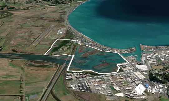
From parking in Humber Street head out left onto Pandora Road and head North over the road bridge and go onto the Lime trail. Follow this along to end and turn right through the truck carpark towards the pub and then left past the camp ground.

Enter the boardwalk and cross over the expressway onto Watchman Rd and head down to the airport. Turn left onto the lime trail at the end that follows alongside the gravel farm road. This winds through a trees in a park like area before turning left at the stock bank and following it back towards the Expressway.

The trail passes over the stock bank, under the express way (20cm flooded at hightide for 20m) and under the rail bridge. Follow the track up to the rail bridge, turn left and cross over it on the disused roadway. Carry on for 500m then take the trail heading off down to the left (marked by an orange post) across the small foot bridge. This last trail flows alongside Pandora Estuary taking you back Humber Street carpark and the start point.

Toilets, changing rooms & showers available at Humber Street toilets. Route takes you through DOC Consevation area. Lots of informative signboards on nature and local history. Water bird life in estuary

If you know of any public toilets near the trail start or on the route, please login and then let us know so we can update this section.

Plenty of angle parking on Humber Street

3 km

5 minutes

No

No

Easy.

Perfect throughout.

Windproof jacket, Cellphone

A drinking fountain is situated at the toilets in Humber Street

None

Bike and dog walkers use these tracks but they are wide enough to pass easily.
At high tide the track back under the railway bridge can be flooded to about 20cm but safe to run/walk through

Westshore Pub
Pandora Rd, Ahuiriri Napier
Great selection of craft beers and food

Takitimu Seafoods
Pandora Rd, Auiriri Napier
Great takeaways

Trail Legend

Adrian Rhodes

Adrian Rhodes

has completed Westshore Conservation Loop 22 times in the last year.

Learn about Trail Legends.

You and Westshore Conservation Loop

As a VIP member you can record private notes for this trail, see all of your times and more.

Register Now

Already have an account? Login now

Trail Reviews

Short and sweet...and (mostly) away from traffic. It is dead flat and maybe 75% is trail. Nice views across the conservation area but a bit exposed to the weather. Note dogs are not permitted.

David Hosking

September 10

Login to submit a review

Trail Running Community

Find people who are interested in or have completed this trail run.

You must register or login to view this feature.

Register Now

Other trails nearby
Once Was An Island

Once Was An Island

Length: 8.4km

Level: Beginner

Kaweka Run and Soak

Kaweka Run and Soak

Length: 22.8km

Level: Beginner - Intermediate

Waipunga Fling

Waipunga Fling

Length: 8.0km

Level: Beginner

Tutira trig

Tutira trig

Length: 8.6km

Level: Beginner - Intermediate

Find more trails and peaks nearby