Last Updated: 21st Sep 2023

Beginner

Save Trail Save

I've done it Done

Sandy Point Loop

Invercargill, Southland

Submitted by Luciana Garcia

Last Updated: 21st Sep 2023

Beginner

Save Trail Save

I've done it Done

Open

Grunt Factor: 14 ?

Gnarl Factor: 8 ?

18.0km

100m

100m

54m


Login as a VIP to see driving directions, distance and time.

Trail Map

Type of Run

Urban fringe

Loop

Totally/mostly flat

Dog Friendly

Native bush

Riverside

Run Makeup

3%
20%
77%

Sealed Road

Farm Road / 4WD Track

Easy Single Track

Average Uphill Gradient: +0.9%

Average Downhill Gradient: -0.9%

Trailhead

Login as a VIP to see the trailhead information.

Estimated Times to Run

2:45

Slow

2:00

Moderate

1:30

Fast

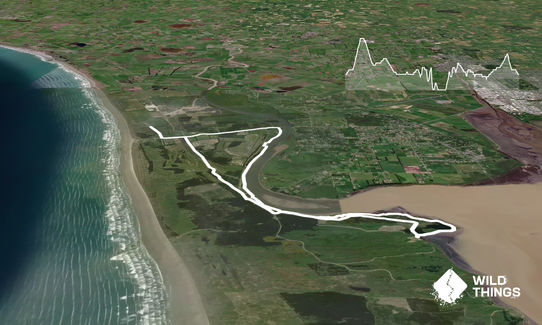
18km loop from Oki Street through Sandy Point. Starts with 3.5km alongside a gravel track up to the Oreti River track in Sandy Point. This track runs alongside the river for another 3km, and then turns into an unmarked track that takes you to the Power Boat Club and Sandy Point playground.

Here you will find another gravel road that follows the river and takes you to the entry of Rovers and Petrie's track. If you take left, you will go on Rovers track, which is just over 3kms and links to Petrie's track looping back to the entry. Petrie's track is around 1.8km. You get back to the start and head back to the playground. There you take left and followed the sealed road for about 500m till you see the mountain bike tracks on your left. There, you run towards the tracks' entry and you will find an unmarked track that runs alongside the mountain bike track's fence and turns into sand and then gravel track. This track goes for 1.5km till you hit Link Rd. Once you cross the road the track continues for another 3kms till Dunns road. When you get to Dunns rd, you turn left and you will be back on the track where you started.
Oreti River and Sandy Point reserve

If you know of any public toilets near the trail start or on the route, please login and then let us know so we can update this section.

No public transport available, Only 15 minutes drive from central Invercargill.

10 km

11 minutes

Yes

No

Easy.

Generally good.

Windproof jacket, Cellphone, Map

None

Not major

Cabbage Tree
Dunns Rd

You and Sandy Point Loop

As a VIP member you can record private notes for this trail, see all of your times and more.

Register Now

Already have an account? Login now

Trail Reviews

Sandy Point has loads of little trails you can put together to make a decent run. This route gives a good taste of many of them. Good variety of trail surfaces. Bit of a strange place to start and finish if you're coming from town, but it's a route I wouldn't have run otherwise so that's not all bad.

Tim Morton

February 2, 2021

A pleasant and convenient loop that traverses a variety of recreational spaces. Easy trails and flat running make this perfect for all levels.
If your are prone to hayfever and planning to run it in pollen season, make sure you're well covered medicinalky as you'll traverse through pine plantations, long grass, scrub with broom, and up and down a dusty gravel road. (Speaking of which, the first and last 800m offers little other than a chance for passing cars to fill your eyes and nose with dust... not a logical place to start and end at all!)

Bryan Stout

January 1, 2021

Login to submit a review

Trail Running Community

Find people who are interested in or have completed this trail run.

You must register or login to view this feature.

Register Now

Other trails nearby
Kilmock Bush Track Plus

Kilmock Bush Track Plus

Length: 6.3km

Level: Beginner

Forest Hill Double Crossing

Forest Hill Double Crossing

Length: 10.7km

Level: Beginner - Intermediate

Hump Ridge Track

Hump Ridge Track

Length: 61.0km

Level: Intermediate

Invercargill to Awarua

Invercargill to Awarua

Length: 10.7km

Level: Beginner

Find more trails and peaks nearby