Last Updated: 5th May 2024
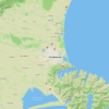
Carters Beach to Kawatiri River
Kawatiri Coastal Trail
Last Updated: 5th May 2024
Open
Grunt Factor: 9 ?
Gnarl Factor: 9 ?
11.1km


Last Updated: 5th May 2024
Kawatiri Coastal Trail
Last Updated: 5th May 2024
Open
Grunt Factor: 9 ?
Gnarl Factor: 9 ?
11.1km
Urban fringe
Out and Back
Totally/mostly flat
Dog Friendly
Native bush
Beach
Coastal
Riverside
Open farmlands
Easy Single Track
Average Uphill Gradient: +0.00%
Average Downhill Gradient: -0.00%
VIP Feature: Send this route to your Garmin account so you can follow the course on your Garmin device.
Become a VIP Member to see the trailhead information.
1:30
Slow
1:10
Moderate
50
Fast
This run follows the Kawatiri Coastal Trail Pūwaha Section along a beautifully created trail from Carters Beach to Westport. This trail brings together a unique combination of native flora and fauna, wildlife and significant Māori archaeological sites. Whilst only a short distance, the accessible route is brimming with history and local secrets.
From Carters Beach Domain follow the very obvious Grade 2 cycle trail heading east along the Carters Beach marine parade. Cross the road and enter a short section of bush before crossing another road before moving inland towards the wetlands. After 2km you reach the towering ship like masts of the Martins Creek suspension bridge, offering elevated views of the wetlands, wildlife and wider West Coast scenery. The trail then continues along a 700m boardwalk through pristine wetlands. This section of the trail is truly a sight to see and a blur of green as you run by.
After leaving the boardwalk you run alongside fields with deep history. These fields are historic Māori Archaeological Sites dating back to around 1350, thought to be one of the earliest New Zealand settlements. looking to your left, you will slowly start to hear and then see the mighty Kawatiri River. Continue along the trail, crossing over the Kawatiri bridge to the 'start' of the Kawatiri Coastal Trail.
Turn around and run back the way you came, enjoying the stunning landscapes from a different view.
Kawatiri (Buller) River, Boardwalk through pristine wetlands, Lowland forest of large mataī, northern rātā and kahikatea trees, Kahikatea forest picnic and rest stop, Martins Creek suspension bridge, Whare Ngāhue (Shelter) with it’s informative interpretation panels, Historic Māori Archaeological Site of International significance dating back to around 1350, Carters Beach Domain and Carters Beach.
If you know of any public toilets near the trail start or on the route, please login and then let us know so we can update this section.
Plenty of parking at the domain near the Carters Beach hall.
1 km
1 minutes
Yes
No
Easy.
Perfect throughout.
Long-sleeved thermal top, First aid kit, Cellphone, Map
Water is available at Carters Beach Domain at the start of the trail.
Donaldos Beach Bar & Takeaways
Carters Beach Domain
https://donaldoscafe.co.nz/
Do you have another suggestion on where to go afterwards for the best coffee / cake / breakfast / brunch / beer?
Trail Legend
Login as a VIP to become a Trail Legend. Learn about Trail Legends.
Fastest Known Times (FKTs)
You and Carters Beach to Kawatiri River
As a VIP member you can record private notes for this trail, see all of your times and more.
Already have an account? Login now
Send to your phone
Scan the below QR code to open this trail on your phone.

Tip: position the QR code in your phone camera screen.
Plan smarter, stay motivated, track your progress, and unlock the full Wild Things experience — while saving along the way.